
West Pennine & Rossendale Walks
Freeholds Top
Date: 28th March 2010
Distance: 7.7 miles
Ascent: 1571 feet
Time: 3 hours 10 minutes
With: On my own
Start Grid Ref: SD935241
Walk Summary:
A train ride to Todmorden was followed by a stretch a long the Rochdale Canal before a climb up on to Freeholds Top and a pleasant return via Gorpley Clough.
Route Summary: Todmorden - Rochdale Canal - The Naze - Foul Clough Road - Freeholds Top - Range Hoyle - Gorpley Clough - Stones Wood - Rochdale Canal - Todmorden
Photos: Click on the photos below to enlarge.


Walk Detail: This was a bit of a novelty in that I arrived at the starting point in Todmorden on the train rather than by car.
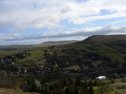
It was a short walk from the train station to the towpath of the Rochdale canal, the path was quite muddy in places and I met a few bad tempered geese along the way. Both path and views improved towards Gauxholme where I left the canal to climb the Naze.
The Naze provided the only real steep gradient of the walk but the path zig zagged up nicely to make the climb fairly easy. The crossing of Inchfield Pasture was a bit soggy in places but I was soon able to stride along the firmer Foul Clough Road. Down to the left I was surprised to see that Ramsden Clough Reservoir had been drained of water.
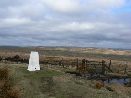
Without much further effort I arrived at the trig point marking the summit of this, one of the few Marilyns in the area. There was a nice pool just next to the trig point surrounded by a not so nice barbed wire fence. The view was quite extensive, to the west was Hailstorm Hill and Cowpe Lowe with the mast on Winter Hill appearing above the former. Swinging round I could see the south Bowland fells, Pendle Hill and numerous South Pennine tops with Black Hameldon and Stoodley Pike the most conspicuous.
The Holme Moss transmitter on Black Hill could clearly be seen, more surprising to me were the large number of other Peaks summits in view, one of which I was sure must be Shutlingsloe.
It was quite windy at the top so I huddled behind a broken wall for some soup before heading for the wall that marks the Yorkshire / Lancashire boundary. After a brief spell along the border I descended into Range Hoyle and followed the path around Gorpley Clough Reservoir.
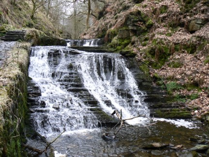
There followed a pleasant if muddy stroll down Gorpley Clough which featured some attractive waterfalls. An unexpected obstacle appeared on arriving at the Bacup - Todmorden road in the shape of a path coverd in freshly laid tar. Timing my leap across to ensure I didn't land on the road in front on an oncoming vehicle I made my way hastily down the road until I could escape up the path into Stones Wood.
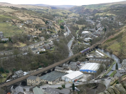
It was worth the extra climb to eventually emerge on a steep track descending back into Gauxholme which featured a bird's eye view of the cramped valley floor with its towns, railways, roads and canal. Once back into Gauxholme it was a simple stroll back along the canal, past the hissing geese in time for the train home.
This was a pleasant walk and I think I'd definitely use the train again to go walking in this area as it was much more relaxing than the usual drive to these parts.


Follow me on ...


